Day 25 – Farewells and on the road again

We were up early to pack and clean up the cabin. We had plenty of time – checkout was 10.30am – but I didn’t want to rush. Roy and I were pretty much packed and ready to go by 9am but there was still the fridge to clear and sort out.

Unfortunately we had to throw out a bit of food – I HATE that, but there was really no alternative – we can’t carry much with us on the plane (although we will take food to eat on the flight because we’re flying with United this time and they are crap). And Sue and Dean have a day of driving ahead (they are dropping us off in Nashville) and don’t have a proper cooler – it wouldn’t fit in the car with us and our bags. They have a couple of plastic bins with lids and some ice from the freezer – and there’s only just enough room in there for all the stuff they actually want to take home and need to keep cool on the drive.

We have put out a LOT of rubbish while we’ve been here – at least three big bags, in less that three days. Cans, glass, plastic, the lot – there is simply no recycling here, so everything goes in the garbage. It gives us the shudders – there are recycling bins everywhere on the West Coast (although we didn’t have one in our Lake Tahoe hotel room – we took the recycling with us). It seems unbelievable in 2017 to be putting all this perfectly good recyclable stuff into land fill. Scary. Some parts of the US have a looooong way to go. Sue and Dean’s rubbish collection at home (which is a bit of a way out of town, in a semi-rural area) is by private contractor – there is no separation of rubbish. I don’t think there is a recycling plant anywhere near them.

Anyway, eventually we were all done – and there were lots of goodbye hugs and a few tears as we said good by to Hal and Teri. It was great to meet them after having heard so much about them from Sue over the years. I was dreading the parting with Sue and Dean in Nashville this afternoon so I tried not to think about it – we all piled back into the car and we were soon back on the road, heading for the magnificent Twin Falls.

IMG_6347

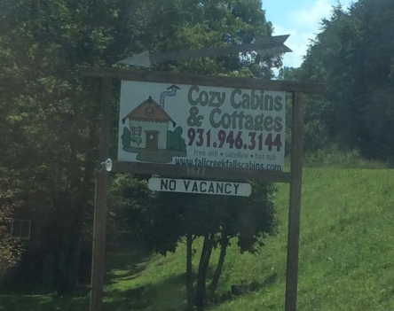
Untill next time… thanks Cozy Cabins!

IMG_6351
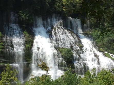
We’d been to Twin Falls on our last trip, but it’s always worth another look. It’s a fantastic set of falls, just downstream what was the confluence of two rivers.

IMG_6353
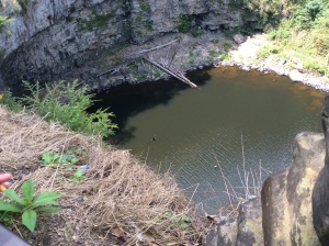
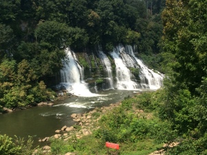
When one of the rivers was dammed to create hydro power, the water trapped in the reservior above forged a new path through the caverns and cracks in the rock of the riverbanks (I think it’s mostly limestone – there are caves nearby).

In contrast the falls  we visited the day before yesterday, there was plenty of water here. It thundered down in hundreds of falls, trickles and sprays, over the layers of rock to the fast-flowing river below, which is also fed by the spill from the hydro plant upstream.

IMG_6366We walked along the track beside the river a little way, to find a good vantage point for photos of the falls.

IMG_6367


It was a pretty hot and humid day out there, but much cooler under the trees that grow on each side of the track.

I took pics of tiny fungi and flowers along the way.

IMG_6365
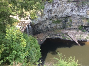
We found a spot where we could step down some rock shelves to get a bit closer to the falls and out of the overhang of the trees along the track.

Yep, pretty certain that this is limestone – hey palaeos, any idea if these are fossils? And if so, of what?

IMG_6377
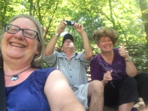
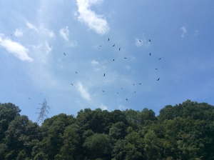
We made our way back over the track and the 60 steps up to the car for the next leg of our journey. As we turned back for a final look, Roy noticed the soaring birds above – turkey vultures (or buzzards), and some crows.

IMG_6378
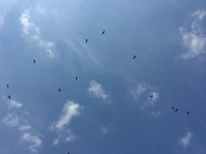
There were stacks of them circling overhead! Just like in the movies after a gunfight or a battle 😉 We all checked our vital signs to make sure we weren’t the ones they were after (they are carrion feeders) and made good our escape.

***

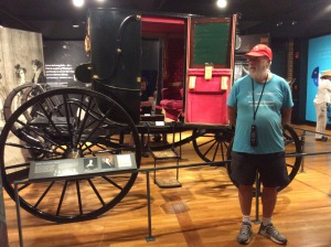
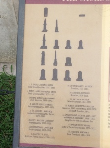
Our next target stop was The Hermitage, near Nashville. This was the home of President Andrew Jackson, one of the three US Presidents who came from Tennessee. The Hermitage is the second-oldest private not-for-profit museum in the US. It’s run by a trust set up in 1887 by Andrew Jackson’s descendants, to preserve the house and grounds and educate the public about Jackson’s legacy. I didn’t know much about Jackson, other than that he was a key political figure in US history, so I was quite interested in finding out more about him. And I like looking at old stuff, too, and getting a glimpse of how people lived their lives in the past.

We arrived at The Hermitage sometime between 1 and 2pm – I thought closer to 1, but Roy recalls closer to 2. Anyway, we quickly gobbled up sandwiches I’d made that morning and braved the blast of the sun (why wasn’t the eclipse today?). At the ticket office, they told us it was a 45-minute wait to get into the tour of the mansion, but that there was plenty to do in the grounds, starting with the indoor section of the museum. We decided to go ahead and buy tickets, if only to get into the air-conditioning of the museum!

IMG_6387There was lots of interesting info there, as well as artefacts from Jackson’s time. Obviously I’ll need to read the book Sue gave us about him, because in this short tour there was way too much to get my head around! He was certainly an expansionist, energetically advocating for the theft of land from native Americans (although he didn’t call it that, of course). He clearly loved his wife and family dearly. He was a strong supporter of the Union, and of the primacy of Federal law over State law. His grandsons, however, fought on the Confederate side in Civil War. He was an extraordinary military leader and strategist.

And he had about 150 slaves running the grounds and house at The Hermitage. There was an audio-guide for the grounds and the house, only some of which I listened to. I wonder how many people took the option to press “play” to hear the recital of the names of all the slaves who worked on the estate? I felt that it was the least I could do.

The grounds, of course, are magnificent, and many historical plantings have been maintained.

The garden attached to the house is beautiful – it has several “rooms” with decorative, commemorative and practical (i.e. kitchen garden) themes. There were nectar-feeding butterflies, moths and bees everywhere.

IMG_6416The garden also contains the small family graveyard. Jackson’s adopted son and his wife are buried there, and their children. The youngest grand-daughter, also called Rachel, had nine children, six of whom also lie there (as far as I can make out, anyway).

IMG_6435
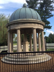
Next to the graveyard is the tomb Jackson had built for himself and his beloved wife, Rachel, who predeceased him by many years, dying only a couple of weeks after he won his first presidential election.

IMG_6433


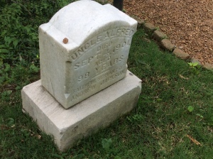
On the other side of the tomb is the grave of one of his long-serving slaves, “Uncle Alfred”, who died at the age of 98. The inscription says: “Faithful servant of Andrew Jackson”. Erk.

The house is meticulously preserved. Jackson had extended and renovated it significantly after Rachel’s death, and the guides take great pains to emphasise that the mansion we see today was not the house that Rachel knew. They have much of the original French wallpaper though, and the furniture, and portraits. And of course those poignant reminders of the humanity of the home’s occupants – the slippers and dressing-gown by the fire in Jackson’s bedroom; the portrait of Rachel that was the first thing he saw on waking and the last thing he saw before going to bed; the grandchildren’s rooms with their dolls and cradle.  I don’t have pics of all this because no photography is allowed inside the house itself – copyright, items on loan etc, etc. The outside is fair game though:

IMG_6449
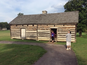
Of course, what has not been preserved, but to the Museum’s credit is brought to the attention of visitors by the guides, are the rough mats on which the slaves slept in the corridors outside the family bedrooms, at the beck and call of their “masters”. Hideous. In the slaves’ hut where Uncle Alfred lived it is permitted to take photos – nothing special, valuable or worth owning copyright over in there.

By the time we’d finished with the house, the garden and the slave quarters, it was almost 5pm and time to go. Sue and Dean still had a couple of hours to drive after dropping us at the hotel. We decided that we’d have a last dinner together, so we went and checked in and then all headed out to O’Charley’s for ribs and steak. These ribs were much better than those we’d had when we first arrived – the meat literally fell off the bone – delicious! We shared a bottle of wine and toasted our wonderful time together over the last week.

When we left the restaurant, it was raining and there was a lot of lightning and thunder around. In the 10 minutes drive back to the hotel it worsened – heavy, driving rain and almost continuous lightning – when Nashville puts on a storm, it doesn’t do it by halves! I suggested that Sue and Dean come in to our room for a little while to give the storm a chance to pass – they were reluctant at first because they didn’t want to get home too late, but as we pulled up in the hotel carpark it was clear that driving wouldn’t be too wise right then.

We went up to the room, switched on the lights and started to check out the satellate and radar weather maps online. We’d only been there a few minutes when – BANG – a massive lightning flash and thunderclap and the room went dark! So glad that didn’t happen while we were in the lift! We had a bit of a laugh, sitting in the gloom and reminiscing about our great week and promising a repeat performance in 2024, when the next total solar eclipse crosses the US. Finally the rain eased, the weather maps showed that the storm was moving on, and it was time to say farewell. We braved what was left of the rain to wave goodbye as Sue and Dean pulled out of the carpark and headed home. We are so grateful for their wonderful hospitality and enduring friendship. I will miss them so much.

The lights came on about an hour later, giving us time to pack our bags for the flight tomorrow and set our alarms before we hit the hay. Tomorrow: Eugene, Oregon via San Francisco. 🙂


Day 23 – Waterfalls, swimming and stargazing

We all had a slow holiday start this morning. Hal made the most amazing and incredibly delicious frittata for breakfast. Mmmm mushrooms… and cheese…

The plan had been to go on a caving trip with an underground river cruise, but Sue rang them at about 9.30am and as we expected, the eclipse crowds were looking for stuff to do – there was no pre-booking, and a two-hour wait for cruise tickets. Since it would take well over an hour to get there, and we hadn’t even had breakfast yet, we decided to save it for another day (our next trip). Who knows what the queue would have grown to by the time we got there! And we have better things to do that wait in line all day.

So instead, we decided we’d have breakfast, those who wanted to could have a dip in the hot tub in our cabin’s backyard, and then we would head out to see some of the waterfalls in the area. Roy and I had been to many of these last time we were here, and we were happy to go and see them again. I put my swimming shorts in just in case – it was a hot day and I find cool water pretty much irresistible. Cane Creek Cascades were on our list, and I knew that there would be a chance to fall in there (I fell in last time 🙂 – the rocks are very slippery).

IMG_6285
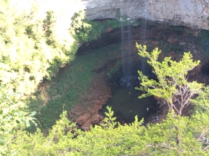
We went to Cane Creek Falls first and took some photos. If you look carefully in some of the pics, you can see people right down the bottom, in the deep pool at the foot of the falls.

IMG_6284


IMG_6287


Roy and I went down to one of the pools at the top of the cascades and had a little paddle. I wanted to get right into the water so changed into my shorts and waded in up to my waist (I kept my t-shirt on, this is Tennessee, not Nariel Creek). It was so good to be in the cool water on such a warm day.

IMG_6292

Above us was the rope and timber bridge that crosses over the falls and cascades. It wobbles around a fair bit, and quite a few kids (and adults too) were very reluctant to try it – we could hear a couple of small children screaming and crying and saying “no!” from where we were. I hope their parents didn’t force them to cross! Hal and Teri didn’t come down as the track was a combination of proper steps and rough rock steps – Hal has a bad knee and I can totally understand his reluctance – my ankle gives me some trouble on rough ground too. Sue and Dean came halfway down and then went back to see if Hal was OK I think.

IMG_6293
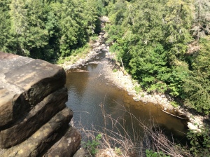
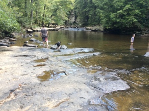
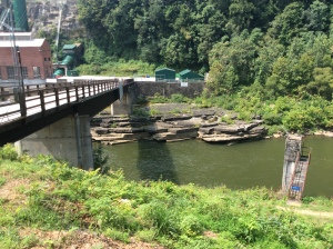
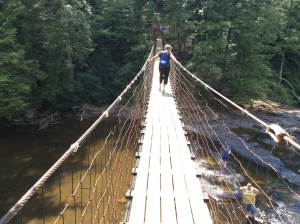
Roy and I didn’t stay long at the pool – we didn’t want to hold everyone else up – but when we got back to the top and found Sue and Dean again, they said that Hal and Teri had decided to go back to the cabin and would meet us there for dinner. So the four of us took a walk across the bridge and back. It is a little unsettling, but it wobbles less if you walk on the middle board. It was fun! And you get a lovely view of the swimming holes in the cascades below.

We then headed down to the pools – a few fairly steep flights of stairs and a bit of a scramble down the rock shelves at the end. Not really climbing, and not really dangerous – but rough enough to require a bit of concentration of finding the best way down and putting your feet in the right place.

There were several adjoining pools, the one in the pics above quite deep (I couldn’t stand up in the middle of it). Roy aimed for the shade in a shallow part and found cool relief in just sitting with his feet in the water. I think Sue had the same idea, but she stayed in the lower pool near where Dean was looking after our bags. I went into the deep water, which was a bit cooler than the higher pool I’d been in before, but still not really cold. Of course I slipped and fell getting in, maintaining my perfect record of elegant and graceful approaches to entering the water.

There were lots of people there – it felt like a day at the beach, but without the beach! Kids, parents, teenagers and young couples, singles, groups of friends and families – and dogs. Apparently dogs are allowed – so they were there having fun too, splashing about and paddling, or sitting panting on the shore watching their humans’ enjoyment of this very beautiful natural feature.

The water was clean and clear, although there was less of it than last time we visited. But there was still enough to create water slides down some sooth sloping rocks into the pool below! Lots of screaming and laughter as kids young and old pushed off from the top of the rock and slid down to the cool shock of immersion in the waterhole. It wasn’t very high – maybe a couple of metres – but high enough to get the adrenalin up and to make sure there was a satisfying splash at the bottom for those who took the challenge!

Feeling nice and cool, we sat for a while on the rocks, talking and watching the fun, and trying to dry off a bit before we had to get into the car again. It was getting on for mid-afternoon when we gathered our bags and headed back up the stairs and then over to where we’d parked the car.

IMG_6297
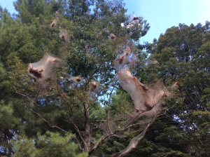
Something I’d forgotten from last time was the big basket-like webs hanging on some of the trees.

IMG_6300
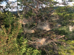
At first I thought they were spiders, but they’re not – they’re small parasitic “bag worms” that attack a tree by spinning these webs and, I assume, feeding off the tree sap (must look that up!)

IMG_6301
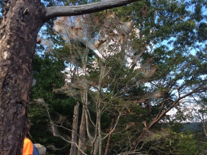
They do eventually kill the tree. Dean said that they’ve been particularly bad this year – and we have certainly seen plenty of them about as we’ve been driving and walking around.

IMG_6307


I wonder if their prevalence is related to lower rainfall and water levels in the creeks and falls.

IMG_6305
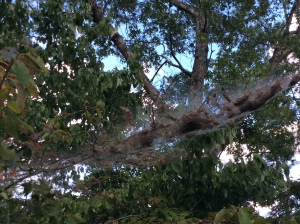
We stopped to look at the main Fall Creek Falls nearby. The outlook here is grand, and a bit reminiscent of the Blue Mountains, the way the layered sandstone cliffs jut out above deep valleys.

IMG_6299

If you ignore the differences between the trees, it would be easy to imagine yourself at a lookout near Katoomba or Blackheath or Wentworth Falls.

The falls are high and graceful, although not as spectacular as last time we were here, when a lot more water was going over them.

It struck me that the interpretive signs we’d seen at each waterfall have been vandalised in the same way. The anti-science creationist brigade is ever active and clearly has zero respect for the freedom of speech and thought that are such a central part of espoused “American values” and freedoms. Appalling.

Back at the cabin, we threw a few bits and pieces together for dinner – Sue made chili and beef, and we had leftovers from brekky and last night, and some crackers and dips and stuff. We were all pretty tired! Sun and water always makes me feel pleasantly weary.

We finished off the evening with a fire in the backyard fireplace, lying back in garden chairs and on stone benches, watching the stars. We saw satellites and planes, constellations and a couple of shooting stars. The night sky here is very unfamiliar to me, and I couldn’t even find the things I do know about – like Cassiopeia, or Orion, who also appears in the northern hemisphere, right-way-up, rather than standing on his head or lying down as we see him in the south. I really miss my homely Southern Cross, but it’s good to see something different for a change.

The sky is clear tonight, and we’re hoping it stays that way for tomorrow’s big event!

Day 17 – Now clockwise! A dam and another lake…

As we’d hoped, Monday brought a lot less traffic on the road than we experienced yesterday. While there were still plenty of holiday-makers around, the weekenders and day-trippers were gone, and it was a lot easier to make the left turn out of our motel driveway than it would have been yesterday morning! It was overcast, but looked like it would clear, which it pretty much did before lunchtime.

Roy was keen to go back to the Truckee River dam and have a look around there. Again we took lunch with us, in the hope of finding somewhere suitable for a picnic. Roy drove again, so that I would have a chance to get some better pics of the lake and Emerald Bay from the road, as well as views of the mountains at this end of the lake. Here’s a selection:

IMG_5817IMG_5820

IMG_5827IMG_5828

IMG_5829IMG_5851

IMG_5879IMG_5899

There are some wonderful twists and turns in the road on the way around to Emerald Bay and the Truckee River. I have some video of going up the hill around a hairpin bend but because I’m too stingy to pay for my WordPress site you’ll have to check that out on Facebook. 😛

IMG_5906
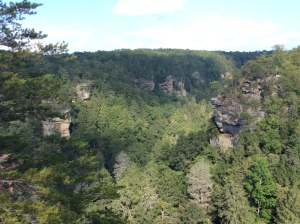
There was plenty of parking near the Truckee River Bridge when we arrived. As I think I said in yesterday’s post, the Truckee River is the only waterway to flow OUT of Lake Tahoe.

IMG_5908

Looking upstream to the Lake

This makes it centrally important to maintaining and preserving the ecosystems of both the lake and the river, and ensuring that the people and industries dependent on both have fair use and enjoyment of both.


IMG_5913Lake levels are strictly monitored and the release of water to the river via the sluice gates at the dam is calculated daily to balance the downstream and upstream (lake) needs. There is also a spillway in case the lake level rises above the dam, but for the most part they use the gates.


IMG_5902

Ducks and clear water

Water quality is a big issue here – the increased population around the lake has led to its clarity decreasing by about a foot a year over the last forty years (see what happens when Roy goes away!!!! Actually, it’s from when they started to use a consistent method to measure it) – from 120 feet to 80 feet. The deterioration is largely due to increased run-off and erosion from development and traffic around the lake, and phosphate pollution. The water must have been amazingly clear in the 1950s when Roy’s family visited, because it’s still pretty good, clearer than most lakes I’ve seen (although nothing beats Crater Lake in Oregon, which we visited on our last trip). But it’s great that they’re raising awareness of the problem and taking action – there are signs everywhere saying “keep Tahoe blue” and info about how to care for the lake.

The other amazing thing is how deep the lake is – and how much water it holds. Its maximum depth is about 500m. It’s also a very high lake – the surface is at an elevation of about 1900m. It’s the second-deepest lake in the USA, after Crater Lake. It’s bigger than Crater Lake, though: Crater Lake (from memory) is six miles across – Tahoe is WAY bigger (as the stats above show).

IMG_5922Lake levels vary according to the volume of snow and evaporation – there is a graph showing the levels over the last few decades and you can clearly see where the droughts are. The drought years (with little snow or other precipitation) resulted in lower levels, and must have placed massive stress on the downstream communities. Since the last drought broke a couple of years ago, the snow intake has increased hugely and the lake is at a healthy level. Only one sluice gate was open when we were there, but there seemed to be a fairly good flow into the river.IMG_5926

Across the bridge and after the turbulence of the flow from the gate has died down, the river is clear, deep and calm.

IMG_5927

Looking downstream

Downstream there are rapids though – yesterday we’d seen lots of people on the river, rafting and kayaking – there are hire places and raft trips you can take. Something to plan for next time we come here!


There is some information about the lake’s first people, and a beautiful blessing of the lake:

IMG_5901

I was wondering whether we could modify Deb Jones’s Acknowledgment song so that we can sing it in all the place we visit here, where the Indigenous people have also been so dispossessed and exploited by white “discovery” and settlement. What do you think, Deb? There are, of course, different stories here, but the relationship to the land and to living with it, rather than taking from it, has clear parallels.

We read about the first white settlers and the “bridge-tenders” – there is now a museum on the site of the first bridge-tender’s cottage, with displays of the baskets woven by Washoe artisans. It makes us sad, ashamed and angry to read that the intricately patterned baskets made by Washoe woman, Dat-so-la-lee, were sold for several hundreds of dollars by a white “patron”. In exchange for the baskets, he provided “room, board and small amounts of cash” to her and her family. Of course, these same baskets are now worth thousands and thousands and are in museum collections all over the world. I wonder how much the Washoe benefit from them now. At least some First Nations in the US have control of some of their ancestral lands and resources. We need to do more of this, both here and at home. Sovereignty and Treaty now!!!

IMG_5900Alas we saw no fish in the river or the lake – Roy suspects that they’ve been pretty much fished out, at least in this area. What a pity, it would have been great to see at least some sign of the fish featured in the signage near the car park. We did see a Stellar’s jay though, down by the river – the flash of brilliant blue in the sun gave it away. I’m never quick enough to get a photo of them, they move around constantly and seem to never sit still!

IMG_5938

Lunch spot – across the outlet to the Truckee River

IMG_5935

Lunch spot – looking out across Lake Tahoe

We crossed back over the bridge and took a short stroll across the park to the shore of the lake, where there were picnic tables and benches.

We found a great spot on a bench at the water’s edge, looking along the western shore of the lake with the river outlet around the corner to our left.

IMG_5940It was a peaceful and scenic place to eat lunch and talk about our trip so far, with the sound of the lake’s tiny wavelets lapping over the rocky shore at our feet (again, see Facebook for the video!)


IMG_5949


I love these quite times with Roy, close to nature and each other. I’m so grateful to him for showing me these places and just being content to be here with me. ❤

IMG_5952We watched a group of Canadian geese make their way across the water towards us, with a number of Californian gulls keeping a respectful distance behind them.

IMG_5956The latter are smaller than the Pacific gulls we’ve seen along the coast, but still larger than our silver gulls at home. This is, indeed, The Life. I took some photos around the shore, and then we headed back to the car, as we were almost out of parking time.

Where to now? – Roy suggested that we go and have a look at Fallen Leaf Lake, which lies to the south of the western side of Lake Tahoe, and was once part of the giant ancient lake we read about yesterday. We had a beautiful drive down there – the road is pretty much parallel to the lake but there are no views of it from the road as far as I could tell (I was driving this time). There is a large camping ground there – it seemed pretty full, either with folks already set up or with reservations, although not sure if it was full or not. There was only a very small public parking area, so we just drove around and checked it out but didn’t see any lake! It can’t be far away though, because people were walking around with towels over the shoulders and kids with inflatable water toys – clearly heading for not-too-distant water.

So we went back out of the campground and took the public road that goes further along the lake. It soon turned into a one-lane road with turnouts at regular intervals to allow passing. As we wound closer to the lake we realised we were heading into a lakeside residential (or maybe “summer cabin” community. Roy couldn’t see how people could live there as the road couldn’t possibly be passable in winter. There were depth indicator poles though, so we figured that maybe they take a snow plough down there. Certainly some of the places seemed to be holiday lettings, but others had the look of permanent residences (at least to me). And I guess they could always get out by boat! Most of the lakeside houses seemed to have their own jetties or ramps.

Although there were signs pointing to a “public beach” area, we didn’t find it, nor indeed did we find any public parking, until we’d driven beyond the end of the lake, up and down the increasingly narrow road hemmed by large, friendly signs like “Private Property” and “Do not park here” and “No trespassing”. Some people driving out seemed to have no sense of the likelihood of meeting a car coming the other way – they were hooning along, and there was a bit of playing “chicken” with the turn-outs. Just a few dickheads with big 4WDs. Most people were as courteous and considerate as most of the people I’ve met in the US (people tell me I think that because I’ve never been to New York, but I’m keeping an open mind.

Finally, on a steep hill, we found a spot to park the car. Frustrating though the drive was (we’d seen only glimpses of the lake), we were surprised and pleased to find that we’d stopped near a beautiful waterfall, where Glen Alpine Creek feeds the lake. Just gorgeous.

IMG_5961

IMG_5962

Some fascinating geology, too – tilted and uplifted rock strata, some of which, from above, reminded me a bit of the Devil’s Postpile, that we visited last time – only the segments are not so regular. I’d love to find out more about this. We followed the creek downstream a bit but didn’t go down to it – the banks were very steep and rocky and I didn’t think I’d be able to get back up once I got down there!

IMG_5969As it turned out, following the creek bed might have been the only strategy for getting a decent look at the lake – we went back to the road and, despite the signs warning us that it was “private”, walked down to the end, where the view was blocked by lantana and there was a closed gate where the road turned along the shore.

IMG_5973Although there was a path around it there was also a very firm sign informing us that this was a “private beach” and pointing us to an invisible “trail” back to the paved road. I wonder how the Washoe feel about that!!! I tell ya, when I rule the world, there won’t BE ANY “private beaches”.

IMG_5978We walked around some of the houses, where we could glimpse the lake between houses and hedges. And, as it happens, a couple of snow ploughs. So they do manage to get in and out in winter! (Although it must be pretty hairy with the cliffside soft shoulders.)

IMG_5977IMG_5979Roy wanted to venture down between a couple of houses so we could at least get a decent view of the lake and so I could take some pics, but itt was clearly private property. I wasn’t confident that “I’m Australian and a socialist and I don’t respect your private property or your monopolisation of the foreshore” would cut it as a defence against a trespass charge, so we turned around and headed back up to the top.

The drive out again wasn’t as scary as the drive in (not quite so many cars to pass, and people driving in weren’t driving as fast as those driving out when we were coming in), and we weren’t on the lake side with its treacherous soft edges. That alone made it a lot less nerve-wracking.

Back on the main road and heading back to the hotel, I felt sad to be leaving Lake Tahoe tomorrow, but incredibly lucky for having seen it at all. What a wonderful, beautiful place.

We had a farewell dinner at Denny’s (yeah, we are SUCH dags) and packed our bags ready for an early departure tomorrow. Although it’s sad to say goodbye to the Lake, we are very much looking forward to our visit with Katherine and Larry tomorrow in Modesto.

IMG_5984

A last look at the lake from the car, on the way to dinner.

Day 32 – More walks and falling water

Our plans to get going nice and early ahead of expected hot weather sort of weren’t quite exactly precisely fulfilled – once we’d had brekky , made sandwiches, filled water bottles and done all the other things that came up and had to be done, it was almost mid-morning.

Cultivated ready for planting

Cultivated ready for planting

Perfect Salem Christmas trees

Perfect Salem Christmas trees

We headed out of Salem, travelling through brown and green fields and Christmas tree plantations towards the Silver Falls State Park, the largest in Oregon and much-treasured by people here.

Moss-covered tree

Moss-covered tree

More moss...

More moss…

... and ferns ...

… and ferns …


It turned out not to be too hot after all (at least, not for me) and the trail to the South Falls was mostly shady, passing beneath huge Douglas firs and other conifers whose names I don’t know…


This forest is very different from those we’ve seen at higher elevations, with a real rainforest feel to it. The undergrowth is green and lush, with lots of ferns and moss – the moss, in fact, has grown over many of the trees, giving them a ghostly Snow-White-lost-in-the-creepy-forest look, although it’s certainly not gloomy or scary here.

... and tiny flowers!

… and tiny flowers!


The sunlight is beautifully filtered through the branches and fir needles, and it’s very warm and peaceful, even with the occasional intrusion of bands of singing children and talkative young folks!

South Falls

South Falls


We walked down the fairly level and gentle track to South Falls, the first of the ten falls in the park. Although it’s been dry here, and Lynnette says that the forest is usually even more green and lush than this, even in late summer, I found it very pleasant indeed, and there was still plenty of water in the falls – certainly enough to make it worth seeing, and enough to give an impression of what it must be like with the greater volume that the spring rains and snow melts provide.

Looking out from behind South Falls

Looking out from behind South Falls

South Falls is a drop of 54m, from the top of a layered lava cliff into a deep, wide pool. The path goes from a high viewpoint right around to the back of the falls, so that you look out through a silver curtain of water and spray – I don’t think I’ve ever done this before with any fall of substantial size (i.e., not counting trickles over the cliffs on the Hawkesbury) and it is a pretty amazing experience! You can really see why they’re called “Silver Falls” – shimmering silver filigree is exactly what comes to mind at this spot.

Erosion under the rock overhang

Erosion under the rock overhang

The underside of the overhanging rock appears to be water-eroded in parts, with rounded indentations that look like they’ve been made by a giant ice-cream scoop. In places it looks a bit the sort of erosion that occurs when water sits in a pool or stream beneath the rock, and varies in level over time – it’s a pattern that you often see in caves. So I imagined that perhaps the whole valley had once been filled with water, that gradually carved out whatever softer rock once lay beneath the volcanic flow above it.

With Lynnette at South Falls

With Lynnette at South Falls

However, later on Lynnette looked up some more information on the geology and it said that some of the patterning was caused by the lava flowing over the trees and plants that once stood in the valley – the treetops left their impressions in the rock as it flowed and then cooled quite quickly above them. Fascinating to imagine that catastrophic event and to stand there today and still see in the rock the formations that tell us about it!!

Lower South Falls

Lower South Falls

The next loop in the track goes further downstream to the Lower South Falls, and so we decided to go on to them and find somewhere to sit and eat our sandwiches on the way. My walking was holding up really well, and I was pretty confident of getting around the next loop, even with a relatively steep climb out to the Visitor Centre and carpark, but not the longer loop after that, which would have involved an additional four miles. That turned out to be the right decision.


Lower South Falls

Lower South Falls

Looking out from behind Lower South Falls

Looking out from behind Lower South Falls

We had to descend a few flights of stairs to get down to the next part of the track, which crossed the river and then wound its way to the Lower South Falls. These falls are not as high (28m), but are wider, with a two-stage drop to the river. Again, the track, hugging the overhanging rock, took us around and behind the curtain of falling water, as magical as the first falls. Just beautiful – and the sound of the water tumbling over the rock is one of the most soothing in the world. I never want to be too far from moving water, whether it’s tidal or falling or flowing.

Soon after the climb to the top of the Lower South Falls, the track splits, with one fork leading back to the Silver Falls Lodge and Visitor Centre and the other to the larger loop of the Ten Falls Trail. While I would have loved to see the other waterfalls, I knew that adding 4 miles to the walk would be pretty hard on me, so I decided to take the shorter loop back, and Lynn said she’d come back that way too. I really wanted Roy to have a chance to take the longer route, though, because I’m really conscious of not wanting to limit his activities because my mobility is limited, and I was very glad when he said he’d take the longer hike and meet us back at the Lodge. I did make him promise to take photos for me though!!

Our trail back was pretty much all uphill, but the climb was made much easier with a series of switchbacks with a much lower grade. Nevertheless, it was a good workout for both of us and we were relieved when the track finally levelled out and neared the Lodge. We stopped off at the little theatre nearby to watch the 10-15 minute film about the Falls. It had been a major logging area and so pretty much all of the current forest is regrowth, although there are still some old-growth stands in some remoter parts of the park. There was also some fairly eccentric “entertainment” there aimed at attracting paying spectators – the one-time owner of the area used to invite people to watch him push cars over the top of the South Falls, and there was an attempt by one bloke to go over it in a canoe, in which failures in the equipment he’d set up to keep the canoe upright meant that it tipped up and smashed him into the rocks at the bottom. He broke both his ankles and many ribs and spent a fair bit of time in hospital for his troubles. Crazy stuff!

Interestingly, the setting aside of the area as a park and conservation reserve came about largely through the campaigning activities of a photographer, June Drake, who around 1900 saw the value of the place and publicised its beauty to the general public through his many photographs of the falls. I thought of Olegas Truchanas and Peter Dombrovkis and thanked the god I don’t believe in for the passion, insight and wisdom of artists.

Lynnette and I then spent a bit of time in the shop – more trinkets were purchased! – and I stuck a pin on Sydney on their visitor’s map and signed the guest book. We went over to the Lodge and I bought a cup of tea (which was actually made with boiling water, yay!) and sat outside to watch birds, chat and wait for Roy. We saw and heard some crows and then with a flash of blue a Steller’s Jay flew right in front of us and perched in a tree nearby. Lovely! Soon enough Roy emerged from the direction of the trail head and after he’d had a bit of a rest we all headed back to the car, very satisfied with a good day out!

Tomorrow we go visiting in Portland and will stay overnight in a motel in Woodland, Washington (State), so that we don’t have too long a drive to Mt St Helens on Monday. Volcanoes rule!!

Day 25 – Birds, giant trees and gorgeous vistas

We are halfway through our trip!

Well, the campsite at Crane Flat is indeed a lot warmer than the one at Lake Silver – I was actually hot when I went to bed. It certainly cooled down in the early hours of the morning, but I just pulled the blankets close around and snuggled up to Roy. My feet were a bit cold but not freezing! My main problem is my hips – they hurt if I lie too long on one side or the other, so I toss and turn a lot – and when I do, I have to rearrange the blankets because they fall off or get tangled… poor Roy!!

Burnt forest - aftermath of last year's Rim Fire

Burnt forest – aftermath of last year’s Rim Fire

More Rim Fire damage

More Rim Fire damage

Sugar Pine cone - the largest of the pine cones

Sugar Pine cone – the largest of the pine cones

Anyway, we did get up early and so we got to do the bird walk – and although we didn’t see that many birds (and I was reminded of how bad my hearing is, because I couldn’t hear some the calls others were hearing), it was a very interesting activity.

It was actually entitled “Birds and Burns”, because it went through, and focused on, the area that was badly burnt last year – the third-worst fire on record in California – they refer to it as “the Rim Fire” because of its location and scale.

And when you get to the end of the trail (which, interestingly, follows an old rail line that was used to bring logs out of the forest before the Rockefeller chap bought it to stop the logging), you get a glimpse of just how extensive the fire damage is.

Post-fire regrowth

Post-fire regrowth

I was interested to compare the regrowth of the various trees with that of eucalypts and other natives – the pines, if they’ve survived, grow green from the top and eventually shed their lower, dead branches, which also protects them from a ground fire reaching the crowns. The oaks sprout in a bushy way from their base. None of them seemed to use the “woolly green jumper” technique of Australian trees, with the leaves shooting directly out of the trunk and limbs. Ah – biodiversity and adaptation! You are miracles indeed!

Yes. Yes, they do.

Yes. Yes, they do.

We saw a few ground squirrels and lots of their burrows! We heard, rather than saw, woodpeckers, and spotted a number of smaller birds, nuthatches and so on. I didn’t get much of a look up close though – we were sharing binoculars and when you’re not used to them, it’s a bit hard to catch sight of fast-moving, tiny birds! Of great interest, though, was a fairly fresh bear scat, right on the trail, which a) proves that they’re here, even if we didn’t see any, b) showed that their diet at this time of year largely consists of vegetation and probably insects rather than animals, and c) provides an answer to that age-old rhetorical question.

Giant sequoias at Mariposa

Giant sequoias at Mariposa

Looking up!

Looking up!

"Tunnel tree" - yep, they drove through this...

“Tunnel tree” – yep, they drove through this…

We dropped back to the campsite to pick up some lunch and then set off for Mariposa Grove, to see the giant sequoias. And wow, they are giants!!! Spectacular again, and a chance to see the impact of the fire adaptation that Erica spoke about on the bird walk. The park management and conservationists realised some time ago that their valiant protection of the sequoia groves from fire had some drawbacks – the existing trees were being saved, but there didn’t seem to be much reproduction going on. Further investigation (core samples and a careful look at how their tightly-packed cones might release seeds etc) revealed a 15-20 year burn cycle that is vital for their reproduction. The fire opens the cones and lets the seeds hit the ground, but even more importantly, it clears away the undergrowth and competing trees so that the seeds can find a place to take root and so that they can draw in enough resources to grow into young trees.

Seeping sap in the Tunnel Tree

Seeping sap in the Tunnel Tree

Giant sequoias are incredibly well adapted for fire – not only in relation to reproduction, but also the sustainability of grown trees.  They protect themselves from fire with a spongy outer bark that holds a lot of moisture and although it scorches it doesn’t catch alight easily; they also drop their lower limbs as they grow so that a ground fire can’t crown easily and kill the whole tree. Amazing! What’s more, their very longevity protects them – they live for many hundreds of years (the oldest ones are over 2000 years old – they saw the same earth as our Huon Pines and predate Christianity) – and so grow huge and strong in the truck and branches – so much so that if felled they do an enormous amount of damage to themselves and the trees around them. Their size meant that it took a team of around 20 men to fell just one, and this combined with the fact that in falling they wrecked about half of their own timber actually made them uneconomic to harvest – so they haven’t suffered the clear-felling fate of so many old-growth trees (including their taller but less-massive coastal redwood cousins, still being logged in California).

Half Dome from Glacier Point

Half Dome from Glacier Point

Looking down into the Valley - 3200 ft down!

Looking down into the Valley – 3200 ft down! That tiny white dot in the middle is the helicopter!

After Mariposa Grove we went up to Glacier Point, which overlooks the Yosemite Valley and has absolutely stunning views of the massive landforms that surround it. Amazing.

From here we could see that both Nevada and Vernal Falls on the Merced River (the “river of mercy” to the early settlers) still had some water flow, although of course nothing like their springtime, snow-melt volume, which must indeed be spectacular.

Overlooking Nevada and Vernal Falls

Overlooking Tenaya Canyon

Glacier Point is over 7000 ft (about 2200m) above sea level, and over 3000 ft above the valley. It’s an incredibly grand vista, looking both out across to the cliffs and falls and Half Dome opposite, and down to the green valley below. We could just make out a white helicopter hovering over the meadow near Curry Village – it looked tiny, like a dragonfly against a tuft of grass!

Overlooking Nevada and Vernal Falls

Overlooking Nevada and Vernal Falls

When Roy was a kid, there was a nightly summertime “fire falls” ritual played out here – on a signal from Curry, almost a kilometre below (as the dead crow falls), they would push a mass of burning coals of the edge of Glacier Point, which would of course glow and reignite in their rush through the air, providing a spectacular light show to people watching in the valley! The practice was discontinued in the late 60s, partly because the crowds attracted to the fire falls were trampling the meadows below, but also because of the emergence of a more enlightened conservationist approach to park management as a natural environment and ecosystem. Given the damage that has been caused to the park by fire, I’m sure it was a wise decision to stop the fire falls – but it must have been an awesome sight, so there is a part of me that’s a bit sad to have missed out on seeing it.

I also remembered today that an important force I left out in yesterday’s musings about the creation of the landscape is gravity. Without gravity, ice and water wouldn’t be following their relentless paths, rocks wouldn’t fall and valleys – whether V or U shaped – wouldn’t have been forged. But is gravity an acceleration or a force? Roy says that he’s fine, scientifically speaking, with gravity being treated as a force. But I think I’m committing a logical error here, anyway, because earth, air, fire and water are kind of colloquial or mythical “forces” and now I’m trying to impose scientific concepts onto them and that’s just silly!

Day 24 – Silver Lake to Crane Flat, Yosemite NP

Frosty the car

Frosty the car

frosty tent

…and the tent! Brrrrrr…

We froze. Well, I froze. Well, we both froze, but only I whinged about it. But there WAS a frost – our picnic table and tent and car were covered in ice. While we were having breakfast, a woman went past walking her dog and told us that at 7am it was 27 degrees. God knows what it was at 5am… my feet were like blocks of ice and my nose was like an icicle. Toes to nose, I was cold!! Probably because the campground is surrounded by mountains – and at this time of year, the sun goes down behind the highest western peak and comes up behind the highest eastern peak – so the ground doesn’t get that much sun (comparatively). And we were on the inner side of the road, with no tree cover at all.

Never mind! When the sun finally peeked over the mountain enough to shine on our campsite just a bit before 9am, the ice on the table and seats sparkled as it melted, each tiny crystal for an instant a lens catching the bright sun before melting and soaking into the timber. We had breakfast, packed up the camp and set off for Yosemite!!

Up Tioga Pass

Up Tioga Pass

We bought petrol in Lee Vining – and then on to the crossing of the Sierra Nevada – the highest we’ve been yet in the USA. Spectacular, spectacular, spectacular… but I would imagine incredibly cruel country, whether in the baking dry of summer or the freezing snowstorms of winter. How anyone found a way across them seems an unbelievable feat – of strength, perseverance and, probably, luck. The pass is called Tioga, which sounds like it could be a Native American name – I will have to look up whether this means the Tioga Pass and Tioga Rd into Yosemite follow a Native American trail. There is surprisingly little information in the park about the first people who must have populated this land, harsh and high though it is.

The road winds up and up, past 10 000 ft, and the mountains rise above you again, almost out of the road in front, it seems. California in general, and the Sierra Nevada range in particular – must be a geologist’s idea of heaven. All the big forces – water and earth – combined to create this astounding landscape and an intriguing mix of igneous, sedimentary and metamorphic forms of rocks and minerals. After the reminder in the Smithsonian Natural History Museum, I’ve had my childhood interest in the formation of rocks and landforms rekindled. I wonder if there’s still time to become a geologist?

Sierra Nevada 1

Sierra Nevada

The idea that everything is created from the elements earth, air (wind), fire and water is kind of right in the case of the earth and the amazingly diverse features of its surface – but with the slight (but important) modification – these are not elements OF which things are composed, they are forces BY which they are created. And California offers all the evidence you need. This land is not “America” – that’s just what PEOPLE call it. This land is far, far older and deeper than that.

Sierra Nevada

Sierra Nevada

People scratch around on its surface and thankfully some of them have recognised that it has meaning to impart and have worked to save important parts of it. They stopped the Devil’s Postpile from being blasted to make a dam – a DAM!!! (And the campaign to save it was led by an engineer, goddess bless ‘im.) One of the Rockefellers BOUGHT logging land and donated it to Yosemite, to be preserved forever. People persuaded politicians to pass the laws needed to enable future generations to see these things as well – and the politicians were willing to be persuaded.

Sierra Nevada

Sierra Nevada

But, for all that – does the land care? Are the mountains aware? Does the fire beneath the earth stop bubbling and bursting through, driving the land apart and rebuilding landscapes? Does the water cease to take with it, particle by particle, a piece of every mountain in every raindrop? Will the next ice age come regardless? (Maybe not!!! We seem to have collectively changed at least the course of climate change…). Will the giant rock plates on which the continents float, those jigsaw pieces that lie beneath land and sea, stop their crushing, moving, crashing, progress, as they jostle for position around the globe?

There are some great cures for self-importance in this world. One of them is the Sierra Nevada range.

Yosemite entrance - Tioga Rd

Yosemite entrance – Tioga Rd

We entered the park and found our way to Crane Flat, where Roy had booked our camping for the next two nights. We’re hoping it will be warmer than last night! The ranger gave us a map and we headed to our site. It couldn’t be more different than those of the last three nights!! No mountains on the other side of the tent door here – instead, tall pine trees and ground squirrels scampering everywhere. Beautiful!

Heading in to the Valley

Heading in to the Valley

Roy and rocks at Yosemite

Roy and rocks at Yosemite

Yosemite Falls (or they would if there was water in 'em!)

Yosemite Falls (or they would if there was water in ’em!)

Steller's Jay at Yosemite Falls

Steller’s Jay at Yosemite Falls

We set up the tent and headed into Yosemite Valley to pick up some groceries – we’re running a bit low – then we stowed the food and caught the Valley Shuttle down to Yosemite Falls – sadly, bone dry at this time of year, but nevertheless impressive in their height and the evidence in the rock of the two magnificent drops of the falls. This must be a sight indeed in springtime, when the snow melt swells Yosemite Creek and tumbles over the top, rushing to the valley floor to once again become a creek, and flowing eagerly into the Merced River. If I needed a reason to return in the spring, this would be it!

Back to the campsite for dinner, and it does indeed seem to be warmer here – I’m still in shirtsleeves as I fire up the stove to cook up fresh onion, mushroom, carrot and broccoli, to be combined with something from a can, vile-looking but moderately tasty and with unconfirmed sightings of meat. AND we had a glass (well, plastic cup) of wine with it, which as I said to Roy makes me feel like it’s grown-up camping…

One of the rangers, Erica, came by to say hello and see if we had any questions – she was very friendly and cheerful (who wouldn’t be, working in this place?) and was pleased when we told her were intending to come to the talk on woodpeckers this evening at the campground amphitheatre, where they have activities, talks and a campfire in the evening. Attend we duly did, and it was a very informative talk indeed, not only about woodpeckers but also the bird research that’s done in the park, habitat and other incidental things that came up as people asked questions. Erica also announced that she would be leading a bird walk the next morning – we think we might join it if we don’t sleep in after our last almost-sleepless night in the freezer!

Day 10 – Above and below ground

All our food leftovers went into the pan for brekky ‘cos we had to check out of the cabin by 10.30am.  It was already pretty warm when we left just before that time. We headed off to the Fall Creek Falls area again to see another set of waterfalls further upstream, the Cane Creek Falls and Cascades.

Cane Creek Cascades

Cane Creek Cascades

There was once a corn mill next to the Cascades, built by a man called Leonard Bickford and his son Charles, where farmers would bring their corn harvest to be ground. It was powered by a turbine placed in the cascades. It worked there for forty years until a flood swept the whole lot away – down the cascades and over the main falls further down – that must have been both terrifying and spectacular. I  wondered if the local Indigenous people had warned the Bickfords not to build there as the Wiradjuri had warned the Gundagai settlers. And whether, like the Wiradjuri, their long-standing knowledge of their country was ignored.

Roy on the rope bridge

Roy on the rope bridge

There was a fantastic rope bridge above the cascades – from there we could see people swimming in the pool below. We could also see fish in the clear water of the upper pool. It was just beautiful there, with the sound of the water and the trees on each side of the gorge that the river has carved out over hundreds of millions of years. The trees are a very different green from ours, and somehow less dour – lighter-leaved and shadier.

This is where I fell in. Ahem.

This is where I fell in. Ahem.

We walked down to the foot of the cascades – there is a deep pool and then rapids leading to the main fall of water into Cane Creek, and lots of people swim there. It reminded me a bit of the Whian Whian Falls where we swam on the tour last year, although about ten times bigger! I took my shoes off to paddle in the shallow water (we hadn’t thought of wearing swimmers, although it was definitely hot enough to swim!) but slipped on some moss and had rather more of a dip than I had intended!  I did consider just sitting there pretending that it was all deliberate and enjoying the beautiful cool water but Roy had seen me go in – rats!!

Millions of years? No!!!

Millions of years? No!!!

Cane Creek Falls and the pool below

Cane Creek Falls and the pool below

Now, here’s something interesting – at the main falls, there is the usual interpretive signage. Check out what’s been crossed out ( I hope you can read it – it’s the word “million” from the phrase “over 200 million years”, in reference to the river’s existence over that time). I think that’s very calculated vandalism. We are in an area of Tennessee in which there appear to be more churches than people – and they have some weird things to say (see below in relation to the cave tour we did). It’s pretty hard to maintain a story of the earth being just a few thousand years old and created pretty much as it is today, right down to the river gorges, when the evidence of a much greater geological story lies before you – and, dammit, those geologists WILL keep making assertions based on that evidence!

Cave pool at Cumberland Caverns

Cave pool at Cumberland Caverns

Awesome!

Awesome!

This brings me to the cave tour, at Cumberland Caverns. This attraction, although recognised as a national landmark, is not in fact a national or state park, but is run by a mob of Christians. So, duly booked-in for our our underground tour, we trouped off to the cave entrance. And here is the problem: in almost two hours underground we heard sfa about the geology – I don’t think the guide even mentioned that the formations are made of calcite crystal, let alone that they are created by acidic water dissolving the limestone through which it flows. She didn’t mention limestone, actually. Or the age of the caverns.

Almost a column!!

Almost a column!!

She was just plain wrong about some things – e.g. that formations grow at about 1 cubic inch every hundred years (this may be true for some and not for others – it’s impossible to determine a single rate of growth because it depends on so many variables, the including the water flow rate, composition and angle of the rock, humidity of the cave (and hence evaporation rate) and  lots of other things. And when someone asked if a few stalactites with flat bottoms had been broken, she said “oh no, some of them just grow like that”. Er… no – they had clearly been broken off, unless they had grown down into a pool of water that had been there for a long time (preventing crystal formation) and then drained away or evaporated when the cave became dry – whichever, it was a stupid bloody answer. She also said that some parts of the cave were “dead” because there was no water in them – when the drops of water on the ends of several stalactites were clearly visible. It drove me nuts – here were all these “teachable moments” in a very beautiful and grand setting of major formations and they were being utterly squandered!! I wanted to take over the tour and give the explanations (learned over many, many Jenolan tours from the time Doug worked there and we went up every weekend) but this is Tennessee, so I politely held my tongue.

But the weirdest thing was the special 10-minute light show in a very grand cavern with beautiful and significant formations, which was all about God (apparently a Voice that lives in a cave) creating everything (including, by implication, the wonders of the caves) in seven days etc etc. Oh, and it appropriated the speech from the Apollo 8 astronaut who told us all to treasure this earth as a great gift from God and other puke-worthy exhortations. Of course we were reminded to appreciate the wonders of The Cave Voice’s creation as we made our way out through this example of His magnificent world. Well, that explains why she didn’t point out the fossils that allegedly exist on the ceiling of the cave.

OK, so these people run the place and they are of course entitled to express whatever views they want to. But I bet stacks of schoolkids go to those tours and instead of learning something of the real wonders of this incredible mix of geology and chemistry, they get nothing but this load of guff. Again, being polite as I am, I didn’t ask why, if formations grow at one cubic inch every hundred years, there appeared to be many more than 400 cubic inches of formation in the canopy we were looking at along with all that flowstone beneath it.

I’m detecting a pattern here – every time I start to think “Oh, it’s OK, the people of this amazing and beautiful country really are just like us” I see or hear some sort of jolt in the cultural comparison – a singularity that seems impossible to define or model or understand from an Australian perspective. And I realise how much I have to learn about how this place works.

Day 9 – More waterfalls … and good times

I made pancakes this morning. To Dean’s horror, they were perfectly OK, despite being made from flour, butter, eggs, milk and sugar. OMG!!!

Twin Falls looking downstream

Twin Falls looking downstream

We then headed out to Twin Falls, in Rock Island State Park. Very impressive, with a lot of water coming down after the last few days of rain. There is a short walk along the river to several vantage points for viewing the falls – it was a bit slippery but the ankle held up OK and I managed to get some lovely photos as well as video of the falls. The sound of them is fantastic.

Twin Falls looking upstream

Twin Falls looking upstream

Close-up - looking upstream

Close-up – looking upstream

These particular falls emerge from the cliff face itself – the river that produces them flows underground through limestone and pours down over rock shelves into the Caney Fork River. Collins River is damned further up (there is a hydro power station just upstream from the falls) and the Twin Falls appeared after the damn was built – the theory is that the river level behind the damn rose and water started to seep under pressure into cavities in the limestone.  It escapes by bursting through the cliffs – and it’s pretty spectacular.

Also spectacular were the many large birds soaring over the deep Caney Fork River valley – mostly hawks but some bigger ones which I think were probably Black Vultures – they are carrion feeders, which seems to upset people, but  I think they do a fantastic job as nature’s cleaning team – they polish off the road kill very effectively.

 Great Falls Power Station

Great Falls Power Station

While we were down by the falls, the power station siren went off, indicating the release of water from the dam. The advice is to move to higher ground when the siren sounds – I’m not sure how far away the spillway is, but even after the sirens stopped there was no perceptible rise in the water level, so maybe they’re just over-cautious in this litigious nation.

Burgess Little Falls

Burgess Little Falls

Burgess Middle Falls

Burgess Middle Falls

Burgess Big Falls

Burgess Big Falls

We moved on (rescuing Dean from an earbashing from an ex-Ranger who was regaling him with stories of his travels and treks) to Burgess Falls, in the Burgess Falls State Park. There are actually three sets of falls – the Little Falls, Middle Falls and Burgess Falls (or Big Falls) itself. Plus there are beautiful pools and rapids over sloping and stepped rock shelves between the more dramatic drops. We were never away from the sound of rushing and falling water as we trekked the 3/4 mile track between Little and Big Falls, via Middle Falls.

Many people have left their names or initials along the track, either on the trees or the railings that line the track. Some are written with markers but others are carved into the timber (alive or dead). People just want to leave their mark on the places they’ve been. Reflecting on that, I realised that I really don’t care about leaving my mark – in fact it’s the mark that such places leave on me that is so much more precious and important to me.

image image

And this place has definitely left its mark – the depth and majesty of its canyons and the rich music of its falling waters, the moss and the lichen and the shade of its forests, and the fact that I’ve experienced all of this in the company of my lovely partner and my friends. This is a special place for Sue and Dean too – they come here regularly and were married at another waterfall park not too far away – and I’m so grateful to them for sharing it with us.

We made our way back to the cabin and Dean cooked up a fantastic BBQ dinner – steak, sausages, broccoli, baked potatoes and corn on the cob, onions and mushrooms fried up on the stove, salad… what a feast! I will need to ride my bike to work every day for a year to counter this overindulgence! After dinner we sat near the fire Dean had built in the fire pit outside the cabin (not too near – it’s still pretty warm out there!) and watched the stars – we could see the milky way quite clearly when we blocked out the garden lights! Like Billy Bragg, I saw a shooting star and wished on it, but it was only a satellite. “Is it wrong to wish on space hardware?” Maybe it’s just the G&Ts…

Back to Jackson tomorrow, possibly via the Cumberland Caverns and a cave tour. 🙂

Day 8 – Off to the waterfalls – oh deer!!

Another big(ish) travel day – a four hour drive (plus some stops for lunch and shopping – I’m gonna do pancakes tomorrow for brekky). Sooze drove all the way – I wasn’t even game to offer to relieve her because I still cringe whenever we make a left-hand turn. I’m really relying on Roy to deal with getting out of Jackson next week when we head for DC!! I might have to try it first on a very very very quiet country road or back street…

Crossing the Tennessee River

Crossing the Tennessee River

Yep, really.

Yep, really.

We headed back towards Nashville but bypassed it to the south and headed for Franklin and Murfreesboro, through Woodbury to McMinnsville, where we stopped for a late lunch and the committing of great sins of consumerism (i.e. shopping at Walmart). Dean was shocked – shocked, I tell you – that I was intending to make pancakes from scratch – i.e. not using pancake mix!!  And Roy selected “America’s favourite tea” – and then later wondered why “it tastes different” – well, obviously, because it’s America’s favourite, not Lipton’s black tea. Ahem.

And don’t get me started on the non-availability of unsweetened thickened cream or canned raspberries or muesli or anything that doesn’t have corn syrup or palm oil in it. But there ARE strawberry Twinkies – Hostess Twinkies as made famous by Tom Robbins in Still Life with Woodpecker. Ah America!! Tennessee!!!  But people are incredibly friendly and polite and generous and cheerful – none of this makes sense in a nation so divided and unequal.

On the way up we saw heaps of high-soaring birds – hawks and buzzards – too far away to photograph or identify species. Not for the first time I cursed myself for leaving the field-glasses behind in Sydney. Dammit!

While we were having lunch, we heard sirens – Sue thought they might be tornado warnings but the people in the restaurant didn’t seem to be too perturbed. When we asked, the waitress (who has only been here for a week) said she thought they were just storm warning sirens – the other people working there said that they go off before ordinary thunderstorms – dunno what they do for tornadoes! Anyway, we made it through the rain and a bit of thunder to the cabins near Spencer by about 5 – checked in and unloaded the car – the cabin is really lovely, a three-bedroom one with a mostly well-equipped kitchen – but no kettle!! – gaaaaah – we have to heat water for our less-than-premium tea in the coffee-maker. After a quick cuppa, we headed up to see the Fall Creek Falls just a few miles up the road.

Oh deer!!

Oh deer!!

On the way to the falls we saw lots of wild turkeys (not the bourbon – actual birds) – but I wasn’t quick enough to get any photos, unfortunately. Maybe tomorrow! As dusk approached, the deer came out to graze along the side of the road – very pretty!

Fall Creek Falls

Fall Creek Falls

The top of the falls

The top of the falls


... and the pool 256 ft below

… and the pool 256 ft below

The falls are beautiful – 256 ft high – lots of water coming over them at the moment after a few days of good rain. There wasn’t much light by this time and there was a lot of mist coming in, hanging about the tops of the cliffs and settling into the valleys, so the photos were a bit hard to get – but you can (hopefully) get a sense of their depth and grandeur. The sound of them and the sight of the water falling were mesmerising – such an amazing spectacle in a natural setting.

Since returning to the cabin all we’ve done is watch TV, drink red wine, talk and laugh our heads off as only old friends can. We’re having a ball just making fun for ourselves, telling jokes and stories and being smartarses with one-liners and little affectionate digs at each other – it’s all about making memories that will sustain us when we’re apart. I feel luckier every day.